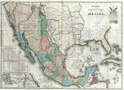
Map Maker: John Distrunell Place / Date: New York / 1847 Coloring: Handcolored
"Description: 11th edition of Disturnell's Treaty Map, one of the most important maps in US History.
In 1836 Texas won independence from Mexico.
In 1848 the Mexican war ended.

Map Maker: John Distrunell Place / Date: New York / 1847 Coloring:
Handcolored
"Description: 11th edition of Disturnell's Treaty Map, one of the most
important maps in US History.
The Disturnell Treaty Map was not an official government publication—it
just happened to be the map that Nicolas P. Trist took with him when he was
sent as peace commissioner to Mexico in 1847. It was to be the map’s inaccuracies
in locating El Paso and the Rio Grande, rather than its correctness, which made
it historically significant in U.S.-Mexican relations. The map showed El Paso
34 miles north and 100 miles east of its true location. The map assumed a lasting
place in history when Nicholas P. Trist used Disturnell’s map in negotiating
the Treaty. Differences soon arose regarding the treaty regarding the actual
depiction on Disturnell's map of the Rio Grande and El Paso." From Barry
Lawrence Rudderman's Old Historic Maps and Prints
By the middle of the eighteenth century about 5,000 people lived in the El Paso area-Spaniards, mestizos and Indians-the largest complex of population on the Spanish northern frontier. A large dam and a series of acequias (irrigation ditches) made possible a flourishing agriculture. The large number of vineyards produced wine and brandy1821 , the El Paso area and what is now the American Southwest became a part of the Mexican nation.
Agriculture, ranching, and commerce continued to flourish, but the Rio Grande
frequently overflowed its banks, causing great damage to fields, crops, and
adobe structures.
Land grants [were] made by the local officials in El Paso del Norte, the best
known and most successful was given to Juan María Ponce De León,
a Paseño aristocrat, in what is now the downtown business district of
El Paso, Texas. By this time a number of Americans were engaged in the Chihuahua
trade, two of whom-James W. Magoffin and Hugh Stephensonqqv-became El Paso pioneers
at a later date...hostilities between the United States and Mexico in May 1846,
Col. Alexander Doniphan and a force of American volunteers defeated the Mexicans
at the battle of Brazito, entered El Paso del Norte." From The
Handbook of Texas Online

And more El Paso history....
In 1849 The Fortyininers cross through El Paso on their way to the California
gold (!) mines.
In 1850 The international boundary commission asssembles to make an official
boundary line between Texas and Mexico.
In 1857 The first mail route was established through El Paso, but the stage
coach operated only in the day time.
In 1871 El Paso County was officially organized.
In 1873 El Paso got its City Charter.
There is a marker today in Pioneer Plaza commemorating El Paso's first newspaper. This first newspaper consisted of a large cottonwood tree on which were posted various public and private notices. It was also used by people passing through town on horseback or by wagon train.